Dear Friends of Centurion Way Supporters,
West Sussex County Council have opened a consultation Traffic Regulation Order CHS9038RC which closes on the 5th August 2021.
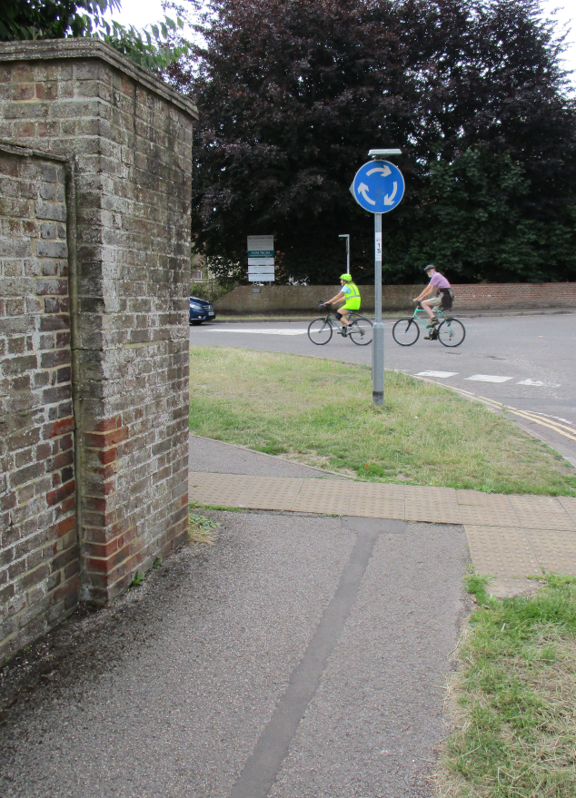
Items iii & iv within the Traffic Regulation Order (TRO) will introduce two parallel crossings at the Sherborne-Rd/Westgate mini roundabout.
Although this may initially sound like a good idea, it puts cyclists onto our pavements riding around dangerous blind corners directly into the path of pedestrians.
In addition, the pavements where cycling will be expected to ride (and also the cycle crossings themselves) do not meet the specified Department for Transport minimum widths for two way shared use cycle
tracks.
Moreover, plans that have recently been released towards the imminent construction of the West of Chichester Development Phase Two Southern Access Road, show that the spine road for this 1,600 new home
development will directly connect at the location of the existing Sherborne Rd mini roundabout requiring virtually all cycle traffic to be transferred onto the existing pavements!
This will effectively severe the National South Coast Cycle Route (NC2) that currently joins Centurion Way into the heart of the City.
Centurion Way was thoughtfully designed by John Grimshaw and constructed in 1995 to follow the former route of the Chichester to Midhurst Railway line.
Great care and attention was paid to using only wide radius turns and to maintain space alongside either side of the path so pedestrians and cyclists have adequate visibility between one another to share the
path in safety.
By contrast, visibility between users will be inadequate when the Sherborne-Rd/Westgate pavements are converted to carry cycle traffic.
Where cyclists are to be redirected onto existing pavements, the few people who remain prepared to ride the Westgate cycle route will conflict with pedestrians.
The inevitable conflict between pedestrians and cyclists will deter vulnerable and elderly residents from attempting to walk along Westgate to access Centurion way.
Young families using child buggies and pushchairs will find it uncomfortable to walk with children on these pavements because bikes will suddenly appear as they approach blind corners.
Of particular concern is the impact the changes will have on our residents who rely on guide dogs or canine assistance dogs.
Zebra crossings on the arms of the mini roundabout would be fine but we feel it is highly undesirable to relocate cyclists onto the pavement at the Sherborne-Rd/Westgate junction.
There are several options for making objections or comments within this Traffic
Regulation Order (TRO) CHS9038RC consultation. You may:
- email your objections, comments and concerns to tro.team@westsussex.gov.uk
- reply to WSCC using the TRO response form on their website. Currently this link gives access but if it fails, try using this more general link covering all WSCC TROs
- send in writing to: TRO Team, West Sussex County Council, The Grange, Tower Street, Chichester, PO19 1RH
Be sure to quote reference TRO/CHS9038/RC and include your full name and address when responding as otherwise your concerns are not able to be taken into consideration by WSCC.
Please join us at the Sherborne-Rd/Westgate mini roundabout at 6pm on Saturday the 24th of July so we can take a photo of everyone to accompany our newspaper story about the Friends of Centurion Way concerns over the plans.
To keep you up to date with what’s happening concerning Centurion Way our web site www.centurionway.org.uk is updated regularly.
Our next meeting is on Tuesday, 27 July 2021 18:00 – 20:00 at the Crate & Apple but if space is not available we will relocate to the Chichester Inn.
We’re on Facebook and you can E-mail us on friends@centurionsway.org.uk.
We would love to hear from you.
Mark Record (on behalf of the Friends of Centurion Way).
following link.
More details of our concerns about the conversion of pavements to shared uses are available below the horizontal line.
Centurion Way was designed as an integral part of Chichester’s walking and Cycling network. It must remain connected to the city centre city by high quality walking and cycling route along Westgate.
John Grimshaw Designed Centurion Way after setting up cycling charity
Sustrans and the National Cycle Routes scheme in 1977. He stepped down
after 30 years in 2008 and today is Honorary Engineer and Trustee of
Greenways and Cycleroutes Limited, which is involved with walking and
cycling issues.

When John was interviewed by the Chichester Society he explained:
Strangely I don’t really mind if the Centurion Way is changed and rebuilt – provided that it is for the better, extends towards the City Centre as a traffic free greenway that is landscaped and planted. Most crucially, Centurion Way must be connected to provide such a direct and attractive route that new residents will see cycling to school, to the Station and the City Centre as the most natural and easy way to travel in Chichester”.
The friends of Centurion Way share John Grimshaw vision and feel strongly that it is unacceptable for cyclists to be forced to share inadequate standards of pavements with pedestrians to enable intense
levels of motor traffic to be routed over an existing National Cycleway.
Cyclists will Round Sharp Blind Corners Directly into the Paths of
Oncoming Pedestrians!
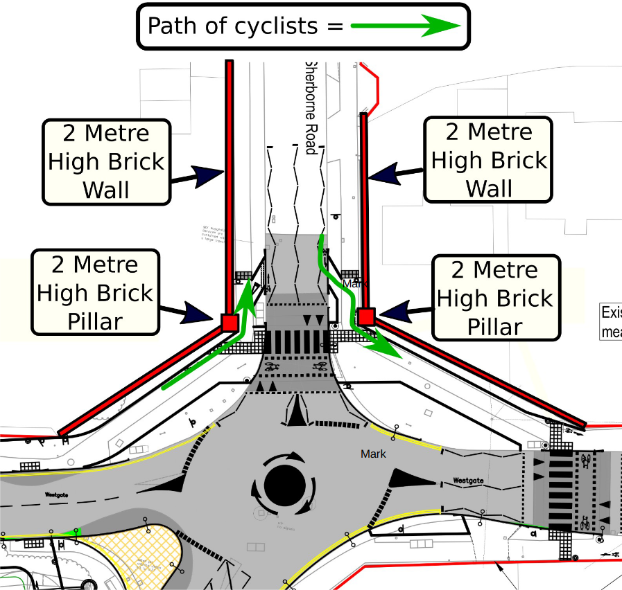
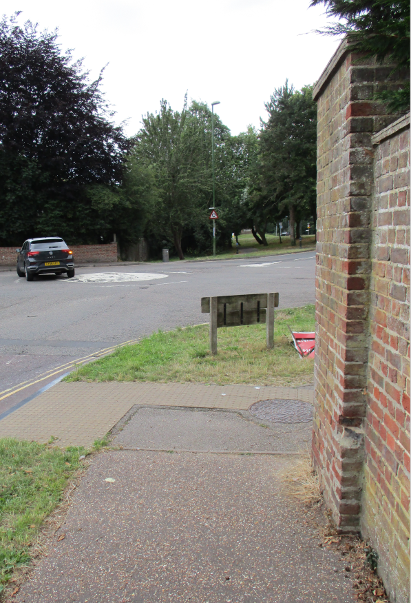
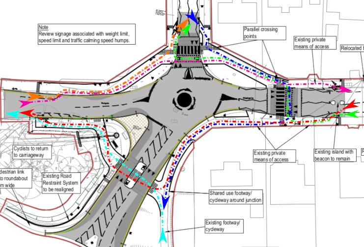
The Northern side of the mini-roundabout is bounded by 2-metre high brick walls. Current proposals re-locate cyclists from the road onto the pavement on a shared use cycle track. Issues are:-
1). Cyclists will round corners with virtually zero forward visibility directly into the path of oncoming pedestrians.
2). The proposed width of sections of shared cycle tracks are well below minimum widths recommended by DfT. Indeed, shared use cycle tracks are inappropriate in this location according to current guidelines.
The image above shows an annotated clip taken from the currently proposed scheme. The route of cyclists around blind corners will clearly inconvenience/endanger pedestrians. Frail elderly members of the
community are particularly vulnerable to injury from collisions with bicycles on these blind corners.
3) Conflict between cyclists and pedestrians will be inevitable on the North West pavement of this roundabout.
DfT Guidlines for Cycle Infrastructure Design LTN1/20 state:
5.9.3 “Objects such as walls, fences and trees should not be sited close to the cycle track on the inside of bends as this will potentially affect the visibility”
This guidance applies to all new cycle infrastructure (as in this case) but is clearly not adhered to in these proposals. In this example, the apex of the corner is bounded by the edge of a substantial brick pillar and wall, giving no visibility between approaching pedestrians and cyclists.
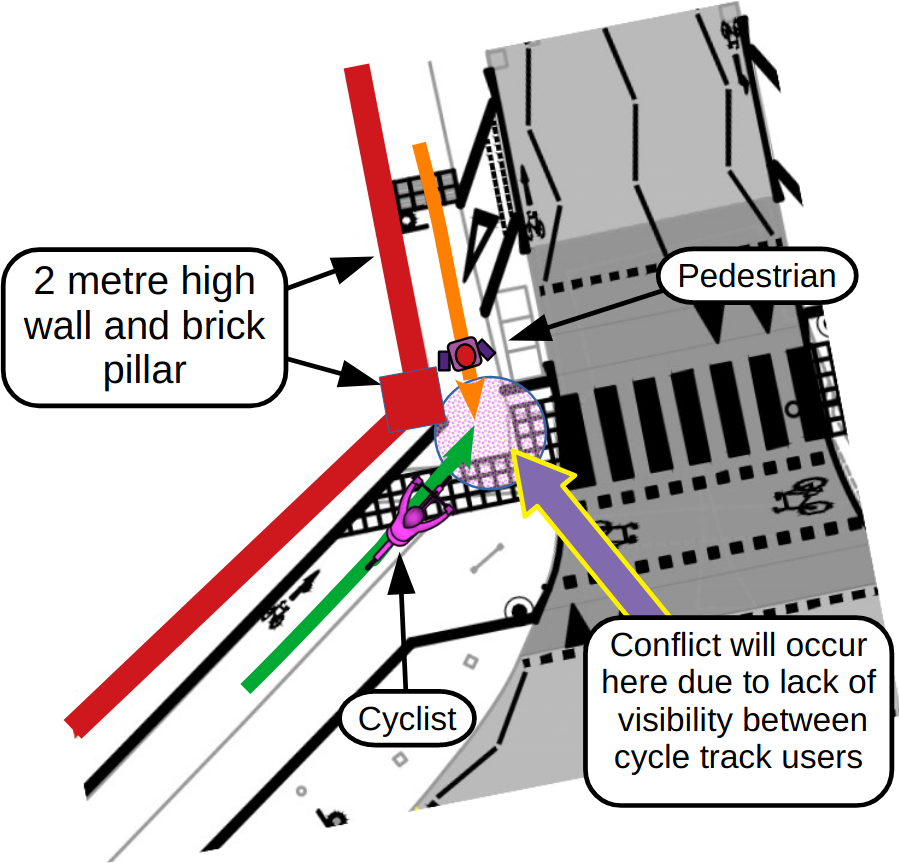
4) Conflict between cyclists and pedestrians will be inevitable on the North East pavement of this roundabout
DfT Guidlines for Cycle Infrastructure Design LTN1/20 state:
5.9.3 Table 5-7 provides minimum horizontal curve radii which should be used for cycle traffic on cycle routes including shared use facilities alongside rural highways where there are few pedestrians.
These radii are based on being able to accommodate the turning space required by the cycle design vehicle (i.e. the actual turning radius of the vehicle) and to provide adequate stopping sight distance at
typical cycling speeds The minimum inside radius given in LTN1/20 Table 5-7 is four metres but at the brick pillars this scheme uses a radius of zero metres!
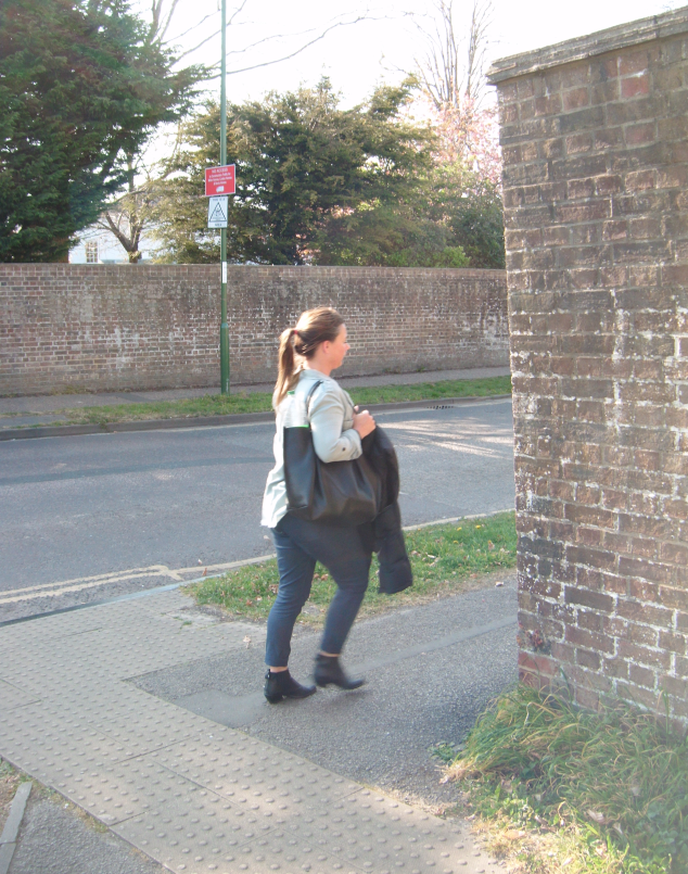
5) Conflict between cyclists and pedestrians is inevitable at this location on the North East pavement of the roundabout
The image above shows the visibility a cyclist will have when rounding the brick pillar that bounds the North East edge of the pavement. The absolute minimum stopping sight distance recommended in
LTN1/20 (Table 5-5) is 17 metres! This distance is usually measured to the extreme inside radius edge of the cycle track. As cyclists approach the apex of this corner, ChiCycle approximate an actual
working SSD of only 1 – 2 metres. This is between 6% and 12% of the minimum distance!
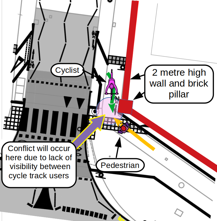
6) Conflict between cyclists and pedestrians is inevitable at this blind corner at the North West pavement of the roundabout.
The image above shows the approaching view of any pedestrian heading south on Sherborne Road, with the proposed crossing to the left. The implications are disastrous for anyone reliant on a mobility
assistance dog, a frail elderly person, or a mother with children using the North West pavement. Current proposals convert this footway into a shared use cycle track!
In addition, Bishop Luffa has approximately 1,600 students who are increasingly encouraged to walk or cycle to school, rather than be driven in. The westward arm of the roundabout (West Westgate) also
links two national cycleways and the Saltern’s way cycle path. Whilst the proposed pedestrian zebra crossing at Sherborne Road makes sense, is it really realistic to re-locate cycle traffic from the road onto
this pavement?
7) Conflict between cyclists and pedestrians is also inevitable at this blind corner at the North East pavement of the roundabout.
The image above shows the approaching view turning north into Sherborne Road of a parent taking children to Parklands Infant and Nursery School or returning from First Steps Childcare at Chichester
College. Can it be justified for families to share space at this sharp corner with busy commuter cycle traffic approaching? Will mobility impaired and partially sighted residents feel safe using the proposed
infrastructure that will have cyclists rounding this sharp corner without the protection of compliance with DfT forward visibility criteria for shared use cycle tracks?
7) On the corner on the South side of Westgate, two way rush hour cycle commuter traffic will be approaching pedestrians on the pavement where visibility is severely restricted. This is unlikely to make
patients of the osteopathy clinic (or any other pedestrians) feel safe using the pavement at this corner. This issue is illustrated in the following image.
Westgate is the only viable walking and cycling route carrying
pedestrians and cyclists from the city centre
It is unrealistic to shoehorn existing levels of walking and cycling onto existing pavements through their conversion to shared use cycle tracks!
A number of locations to the west of Chichester create substantial volumes of pedestrian and cycle traffic that could not safely use the proposed narrow sub standard shared use pavements.
A) Whitehouse farm housing development creating 1600 new homes
B) National South Coast Cycleway NC2
C) Saltern’s Way Cyclepath
D) Tesco Hypermarket (both shoppers and employees walk and cycle)
E) Bishop Luffa School with approximately 1,600 students and teachers
F) Chichester College and First Steps Nursery, 15,144 students, of whom 4,373 are full time students
G) Parklands Council Estate, approximately 2,500 residents
H) Centurion Way, counter estimates 1000 journeys made per day
I) Parklands Community Primary/Infant/Nursery School
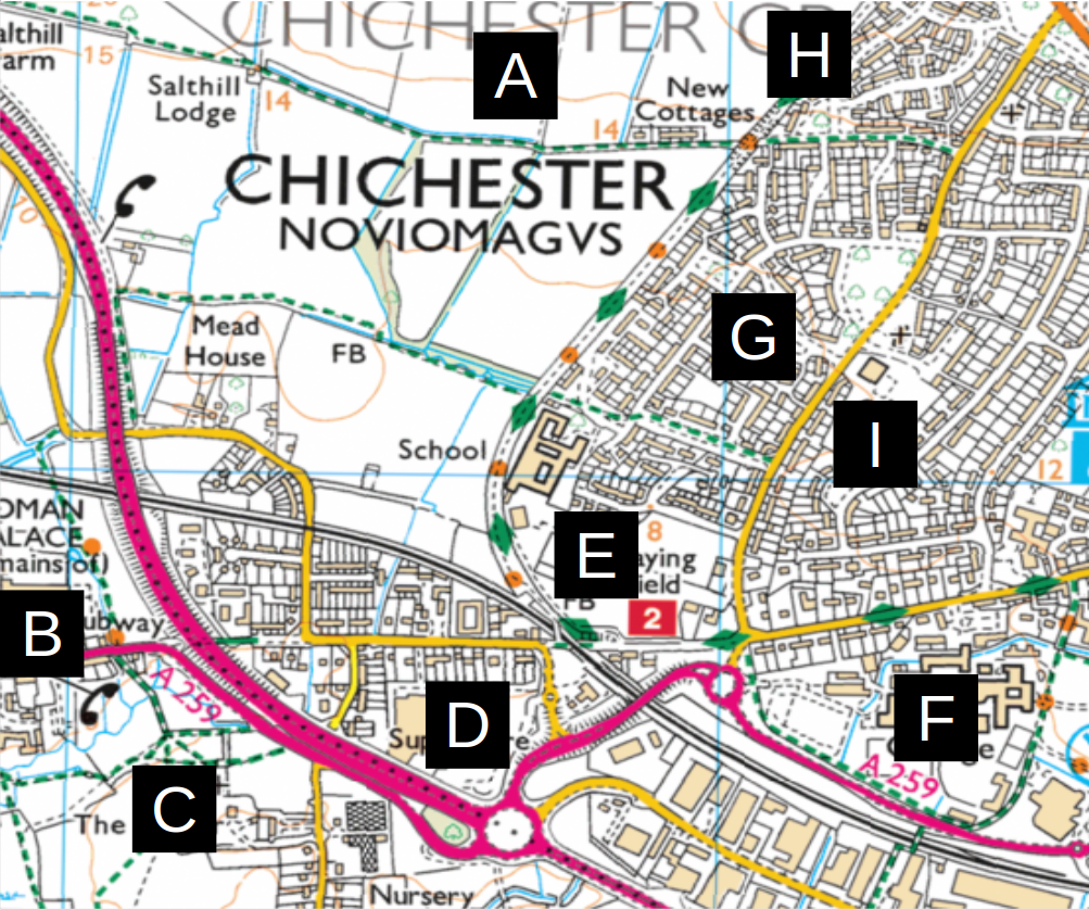
The coloured lines in the diagram (shown below) represent paths and desire lines that cyclists are likely to follow after the proposed conversion of the footways into shared use cycle-tracks.
This design will result in conflict that will particularly disadvantage vulnerable pedestrians. Parents pushing prams or holding a child’s hand, elderly or disabled pedestrians will be unable to avoid walking on narrow shared use cycle-tracks if they need to negotiate this junction.
Unsuitably Narrow Pavements are Proposed for Conversion into Shared
Use Cycle Tracks!
DfT Guidelines for Cycle Infrastructure Design LTN1/20 stipulate that:
Where a cycle track is bounded by a vertical feature, people will not be able to use the entire width as they will naturally be wary of riding immediately next to walls and kerbs. Designers should provide additional width as shown in Table 5-3.
As at Sherborne Road, on the north-side where there are adjacent features such as a two-metre vertical wall, LTN1/20 indicates additional width of 0.5 metres should be provided in addition to the 3 metres minimum recommended width for shared use paths. Total 3.5 metres.
The proposed scheme ignores DfT minimum width guidelines where shared use tracks are bounded by vertical features as illustrated in following two diagrams.

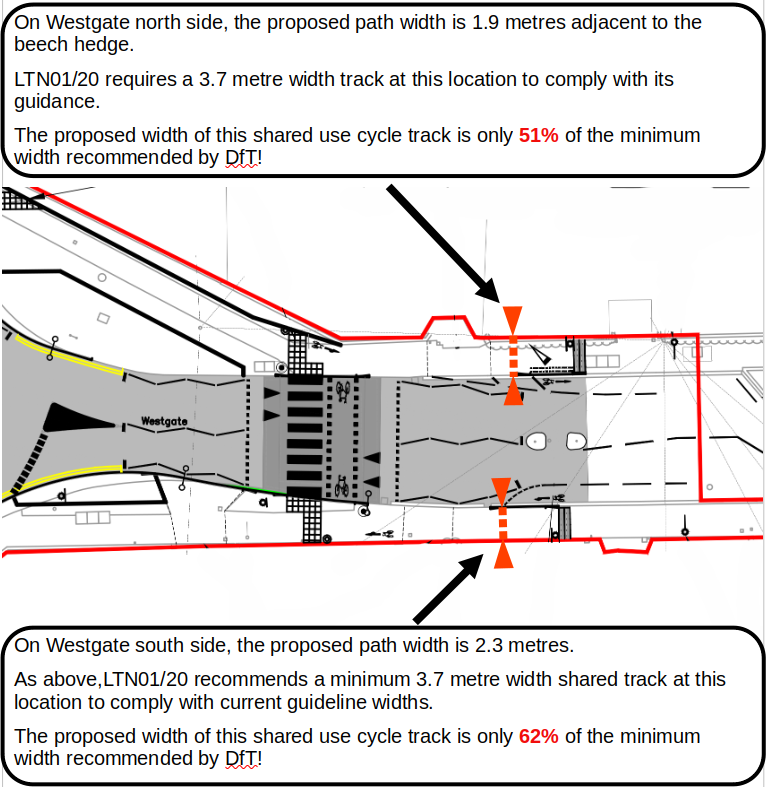
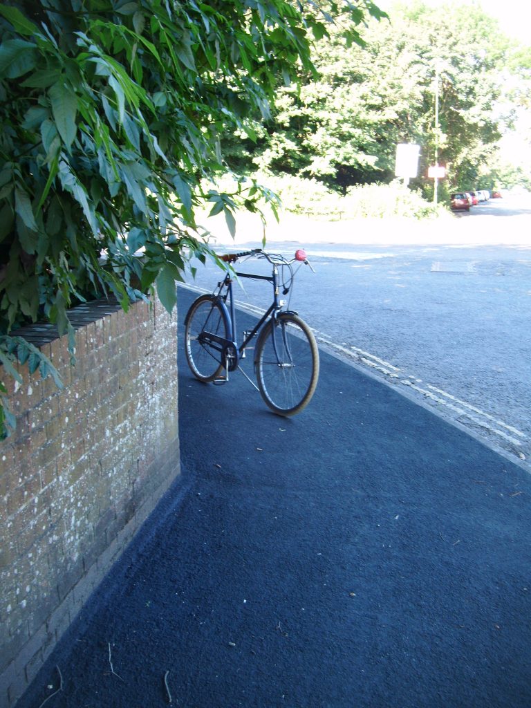
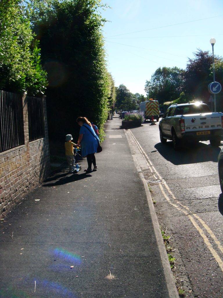
The TRO proposals runs a cycle track past a mature beach hedge that encroaches a long way over a pavement that is below the specified width for shared use cycle tracks. The image below illustrates the
narrow gap between the hedge and the kerb. It is difficult to imagine the adult and infant shown in the image below, sharing the space between the hedge and the road with fast moving morning commuter
traffic including wide cargo bikes and parents pulling bicycle child trailers also using this pavement.
These design proposals fail to follow current advice given by all relevant DfT guidelines. This will result in discrimination towards vulnerable pedestrians in contravention of the 2010 Equality Act.
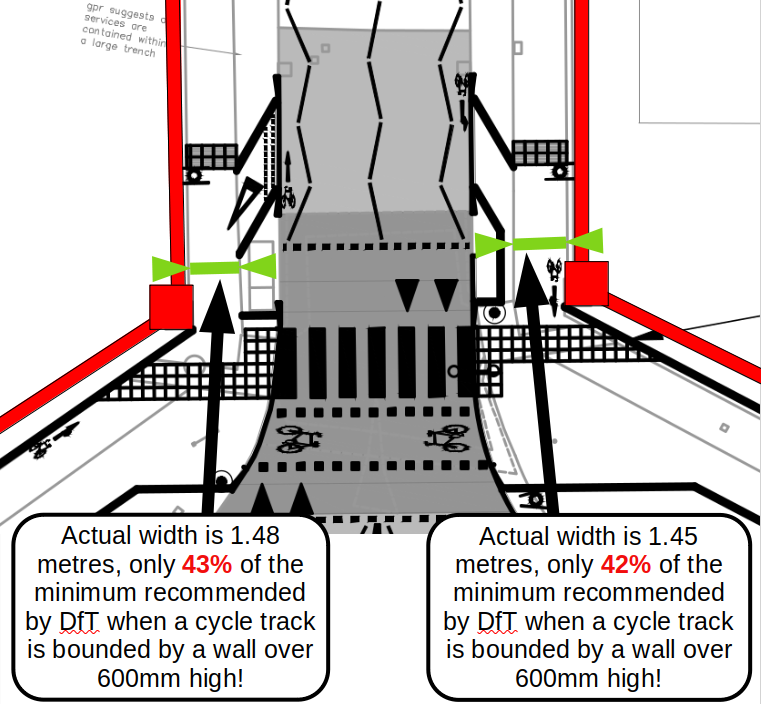
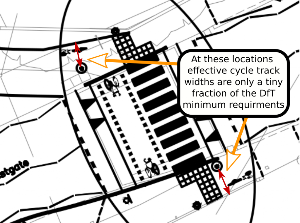
In positions where yellow globes are proposed at each end of the Westgate parallel crossing, significant difficulty will arise if these are mounted onto vertical posts rising up from the pavement. The
effective width at this section of the shared use cycle track would then be only a tiny fraction of the DfT minimum for shared use facilities. This is illustrated in the diagram below.